
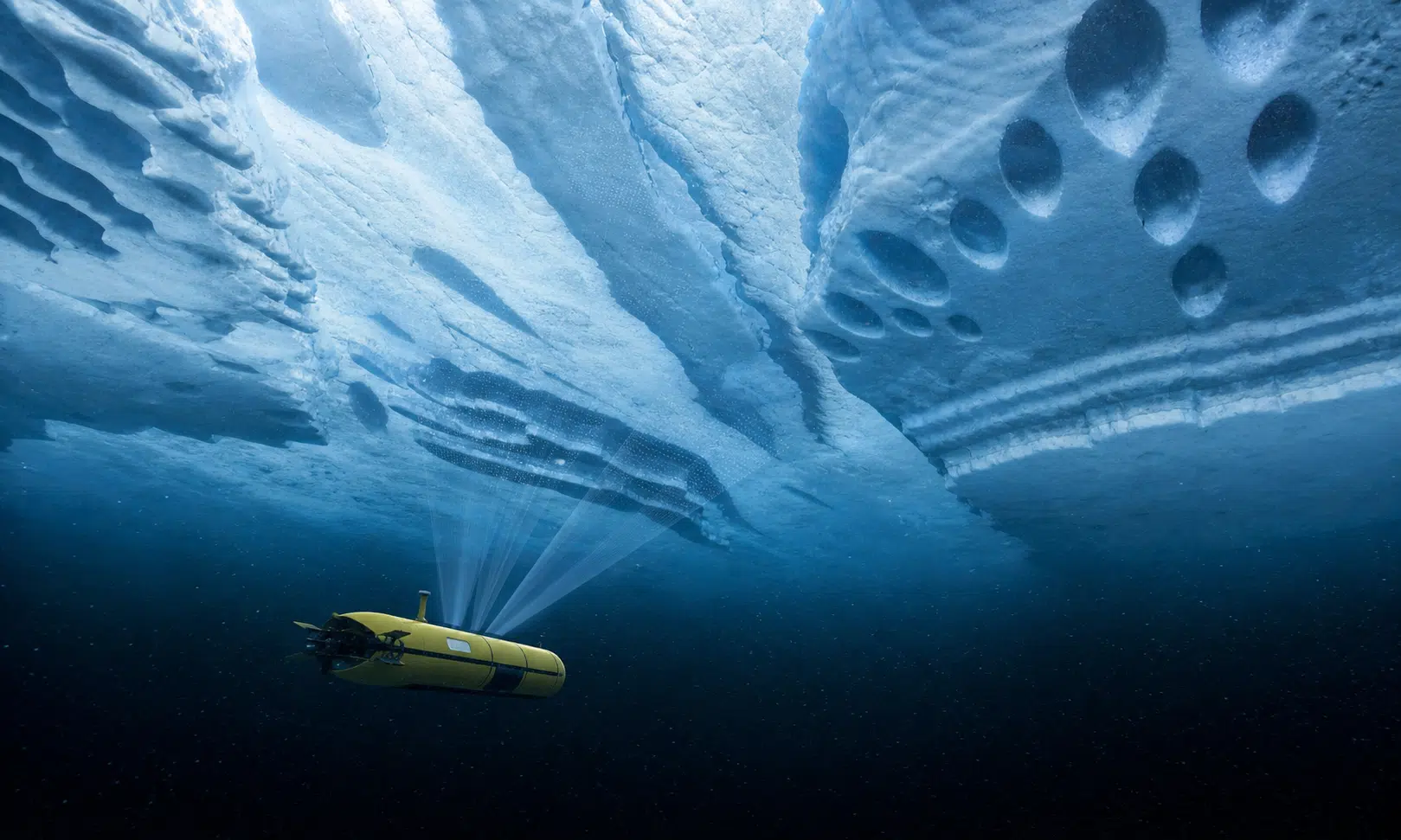

A robotic submarine named Ran gave researchers an unusually close look at the underside of West Antarctica’s Dotson Ice Shelf before it disappeared during a later expedition. The important correction is that Ran was not simply an Australian Navy submarine, as some versions of the story suggest. It was an autonomous underwater vehicle used for polar research, sent into a place where ships, divers, GPS and ordinary inspection tools cannot operate.
The result was not evidence of buildings, seafloor activity or artificial structures. Ran mapped natural features carved into the base of the floating ice shelf: terraces, channels, widened fractures and teardrop-shaped pits. Those shapes matter because they show how uneven the ice base can be, and why satellite views alone cannot explain everything happening beneath a floating Antarctic shelf.
For readers trying to understand the practical importance of the discovery, the useful comparison is not between rival products. It is between ways of seeing the ice. Satellites can track surface height, movement and large-scale thinning from above. A vehicle like Ran can scan the ice from below, where ocean water actually meets the shelf.
What Ran Actually Mapped Under Dotson
Ran surveyed the hidden cavity beneath Dotson Ice Shelf during a 2022 expedition. Reports on the study describe the vehicle traveling more than 1,000 kilometers under the shelf over the campaign and reaching about 17 kilometers into the cavity. Using upward-looking sonar, it mapped roughly 140 square kilometers, or about 54 square miles, of the ice shelf’s underside.
That area is small compared with Antarctica as a whole, but the detail was unusual. The underside of the ice was not a plain, flat surface. It included stepped terraces, smoother eroded areas, channels and pits shaped like teardrops. The survey also showed fractures whose lower sections had been altered by melting.
The features were hidden from satellites because they are on the base of the floating shelf, facing the ocean rather than the sky. That is why the mission drew attention from oceanographers and glaciologists: it connected visible ice-sheet concerns with a less visible process happening at the ice-ocean boundary.
Why Under-Ice Surveys Beat Surface Views For This Question
A satellite can watch an ice shelf from space, but it cannot directly image the shape of the ice base. Ran approached the problem from below. That made the mission riskier, but it also made the data different.
| Method | What it can show | What it can miss |
|---|---|---|
| Satellite monitoring | Surface elevation, broad thinning patterns, ice movement and large regional changes | Fine details on the underside of the shelf, including small basal channels, pits and melt-shaped terraces |
| Autonomous underwater vehicle survey | High-resolution sonar views of the ice base and nearby ocean conditions inside the cavity | Only the area the vehicle can safely reach and return from; missions are expensive and technically fragile |
| Computer modeling | How ocean circulation and ice melt may evolve across larger areas and longer periods | Fine-scale shapes and processes that have not yet been measured directly |
This is the core tradeoff. Satellite data gives scale and continuity. Underwater vehicles provide close detail, but at much higher risk. A model can test future scenarios, but it is only as useful as the physics and observations built into it.
Ran’s survey does not make satellite monitoring obsolete. It shows why the two types of evidence need each other.
What The Terraces, Channels And Pits Suggest
The study behind the survey links the mapped shapes to the way ocean water moves beneath the shelf. In West Antarctica, relatively warm, salty deep water can reach the underside of floating ice shelves. “Warm” is relative in this setting, but water only slightly above the freezing point can still melt ice when it is delivered steadily to the ice base.
The maps suggest that melting under Dotson is not best understood as a smooth sheet being shaved evenly from below. Different parts of the base appear to be shaped by different flow conditions. Some areas show terraced steps. Others show smoother eroded surfaces, channels and pits.
Researchers have connected the faster-melting western part of Dotson with stronger currents and greater heat delivery. The teardrop-shaped pits are among the more distinctive features. They have been discussed as signs of rotating flow near the ice-water boundary, where moving water interacts directly with the ice surface.
That does not mean every shape has a complete explanation. The value of the survey is that it gives scientists a sharper set of physical clues. Instead of estimating melt only from broad thinning patterns, they can compare models against actual mapped shapes under the shelf.
Why Ran’s Disappearance Matters
Ran disappeared during a return mission in January 2024, when the team went back to Dotson to repeat surveys and look for change. The vehicle completed one dive but did not resurface at the planned meeting point. Searches using acoustic instruments, helicopters and drones did not recover it.
That loss underlines the difficulty of this kind of research. Under hundreds of meters of ice, real-time control is limited. GPS and radio signals do not work through the ice and water in the way they do at the surface. An autonomous vehicle must follow planned routes, use onboard systems and acoustic navigation, and still find its way back through a dark cavity beneath a moving ice shelf.
The disappearance also makes the 2022 data more valuable. Ran was one of the few vehicles capable of this type of polar under-ice work. Losing it did not erase the survey, but it made repeating the same measurements harder.
What This Means For Sea-Level Research
Floating ice shelves do not raise sea level in the same direct way as land ice entering the ocean. Their role is still important because they help restrain the glaciers feeding them from inland. If an ice shelf thins, weakens or retreats, the glaciers behind it can lose some of that resistance and move more ice toward the sea.
Dotson is part of the West Antarctic system, a region watched closely because of its possible contribution to long-term sea-level rise. The under-ice survey does not provide a simple forecast for coastal flooding. It does, however, improve the evidence base for the models that feed those forecasts.
For coastal planners, insurers and infrastructure teams, the practical lesson is that sea-level projections depend on details that are hard to measure. The shape of an ice shelf’s underside, the path of warm water and the way fractures widen from below can all affect how scientists estimate future ice loss.
The Real Takeaway
The story is easy to oversell if it is framed as a mysterious submarine discovery. The stronger version is more specific: a research AUV mapped a hidden Antarctic ice surface in rare detail, then was lost during a follow-up mission. The features it found appear to be natural melt-shaped structures, not artificial objects or proof of unusual seafloor activity.
That may sound less dramatic, but it is more useful. Ran showed that the underside of Dotson Ice Shelf is physically complex, with terraces, channels, fractures and pits shaped by ocean water. Those details help explain why direct measurements beneath ice shelves remain important, even in an era of powerful satellites.
The vehicle is gone. The maps it returned are still doing the work: giving researchers a clearer view of how the ocean can reshape Antarctic ice from below.