

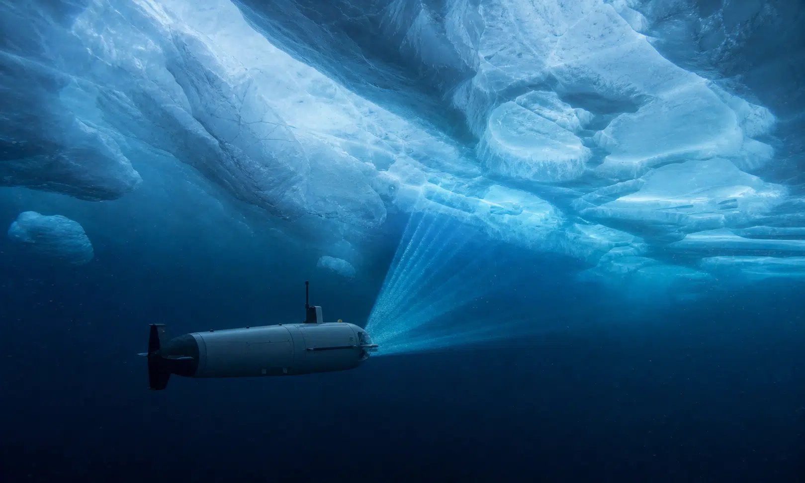

An autonomous robot submarine sent beneath Antarctica’s Dotson Ice Shelf found a hidden landscape of terraces, channels, pits, and fractures before it later disappeared under the ice.
The vehicle, named Ran, had been mapping the underside of the floating ice shelf in West Antarctica. Its sonar scans revealed features that cannot be seen from satellites, including step-like ice formations and teardrop-shaped depressions carved by meltwater and currents.
Ran’s final loss has drawn attention, but the data it returned before vanishing may be more important. The maps show that melting under an ice shelf is not smooth or uniform. Instead, warm ocean water appears to attack the ice in uneven, highly structured ways that could matter for future sea level projections.
What Ran was sent to study beneath Dotson Ice Shelf
Ran was an autonomous underwater vehicle, meaning it could navigate without a pilot while operating far below the ice. The work was led by Anna Wåhlin, a professor of oceanographic physics at the University of Gothenburg, whose research focuses on how ocean currents erode Antarctic ice shelves from below.
During a 2022 field campaign, Ran spent weeks moving through the cavity beneath Dotson Ice Shelf. The vehicle completed a series of under-ice missions and mapped about 54 square miles of the ice shelf’s underside.
The goal was to understand why different parts of Dotson appear to melt at different rates. The eastern side of the ice shelf is thicker and has been melting more slowly, while the western side is thinner and loses ice faster.
That contrast is difficult to explain from the surface alone. Satellites can measure changes in height and thickness, but they cannot directly show the shape of the ice base hidden below hundreds of feet of ice.
Ran filled in part of that missing view. Its sonar instruments scanned the underside of the ice shelf and built detailed maps of a place that had previously been almost completely inaccessible.
The strange structures found under the ice
The maps revealed a surprisingly varied underside. In some areas, the ice base was organized into flat plateaus and terraces, almost like broad steps. In other areas, the ice was smoother, with channels, grooves, and scooped-out depressions.
Some pits had a teardrop shape. The source measurements describe examples reaching roughly 984 feet long and about 164 feet deep. These forms appear to have been shaped by currents flowing close to the ice base.
The eastern and central parts of the mapped region showed more of the terraced terrain. The western side, where melting is stronger, showed smoother surfaces and channel-like features.
Those details matter because they show that the underside of an ice shelf responds to water movement in different ways. Slow-moving water may leave stacked ledges as it melts layers of ice. Faster currents can create smoother, more eroded surfaces where turbulent mixing brings heat against the ice.
In plain terms, the bottom of Dotson Ice Shelf is not just thinning like a flat sheet. It is being carved from below.
Why warm ocean water matters
Around Antarctica, relatively warm salty water from the Southern Ocean can move onto the continental shelf and reach the underside of floating ice shelves. This water is often described as Circumpolar Deep Water.
When it reaches an ice shelf cavity, it can melt the ice from below. That process is known as basal melting, and it is one of the major reasons scientists study places like Dotson.
The Ran data suggest that warm inflow is focused more strongly on Dotson’s western side. Colder water appears to offer more protection to the eastern side, helping explain why the two sides of the same ice shelf can behave so differently.
Satellite measurements have already shown that some melt channels in the region are losing ice quickly. Ran’s maps add the missing shape of the ice base, showing where that melt may be concentrated and how it may be guided by currents.
This is important for ice-sheet models. Many models simplify melting beneath ice shelves because detailed under-ice observations are rare. Ran’s data show that terraces, channels, and pits can create a more complicated pattern than broad averages suggest.
Fractures may guide hidden melting
Ran also imaged fractures cutting through the ice shelf. Some appeared widened and smoothed at their bases, consistent with melting along the lower parts of the cracks.
Available satellite records suggest that some fractures in the area have persisted for many years, possibly since the 1990s, but the exact history and melt pattern of each crack is harder to confirm from the surface alone.
Even so, the under-ice scans point to an important possibility: fractures may act as pathways for warm water. When water moves through narrow openings, it can concentrate heat along the ice walls and deepen existing weaknesses.
That would make cracks more than surface features. They could become hidden routes for ice loss beneath the shelf.
This is one reason the Ran mission is valuable even after the vehicle was lost. It showed how small-scale structures can influence large-scale stability.
What the findings mean for sea level
Ice shelves already float, so their melting does not raise sea level in the same direct way as melting land ice. Their importance comes from the role they play as brakes.
A floating ice shelf can help hold back glaciers that rest on land. If the shelf thins, weakens, or breaks apart, the land-based ice behind it can move faster into the ocean. That is when sea level rise accelerates.
West Antarctica is a major focus for this kind of research because many glaciers there flow into deep basins that can be reached by warm ocean currents. Dotson is one piece of that wider system.
The data from Ran show that researchers need to understand not only how much warm water reaches an ice shelf, but also where it goes once it enters the cavity. Channels, terraces, pits, and fractures may decide which parts of the ice weaken first.
That makes the under-ice landscape a key part of the sea level puzzle.
How Ran disappeared
Operating beneath an Antarctic ice shelf is unusually difficult. Ran had to work without the kind of real-time contact used by surface vehicles. Under thick ice, radio and GPS links are not available in the same way they are in open air, so the submarine relied on its own navigation systems and acoustic instruments.
Missions could last for many hours, sometimes more than a day. During that time, the team had to wait for the vehicle to return before knowing exactly what had happened below.
After the successful 2022 work, researchers returned to Dotson and sent Ran under the ice again to extend the maps and collect more measurements. The vehicle did not come back to its planned pickup point.
Attempts to contact it failed. Searches did not find a signal or debris. Without live video or telemetry from the final moments, the team could only consider possible causes, including a mechanical failure or a collision with difficult ice terrain.
The loss was serious, but it did not erase what the earlier missions had already delivered.
A rare look at Antarctica’s hidden melt machinery
Ran’s maps changed the view of Dotson Ice Shelf from a broad, remote slab of ice into a detailed under-ice landscape shaped by moving water.
The strange structures it found are not just curiosities. Terraces may record slower, layered melting. Teardrop pits may mark focused current action. Channels and fractures may steer warm water toward vulnerable parts of the shelf.
Together, those features suggest that ice shelf melting is controlled by fine details that are easy to miss from satellites and difficult to include in computer models.
For researchers trying to understand West Antarctica’s future, that is the lasting value of the mission. Ran disappeared beneath the ice, but the data it returned offers one of the clearest looks yet at how the ocean can carve an Antarctic ice shelf from below.